Map
The map is an interactive page that allows you to view your paddocks like a farm map.
Layout
Here is a quick overview of what you will find on the map:
| Feature | Description |
|---|---|
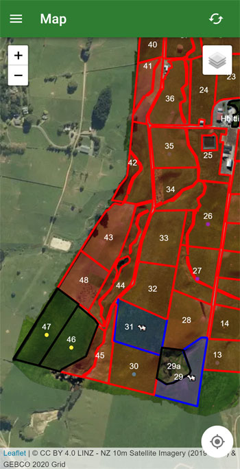
| 🟥 Red boundary (with a paddock number/name) | These are your paddocks, tap on them to open up a menu for the paddock |
| 🟦 Blue boundary | These are paddocks that are currently being grazed |
| ⬛ Black boundary | These are paddocks that have been removed from the paddock queue |
| Dots under paddock number/name | These dots correspond to the tags that are currently on the paddock |
| Plus and minus buttons in the top left | The controls allow you to zoom in and out without having to pinch |
| Layer button in the top right | This button opens a menu that allows you to control the layers (see more below) |
| Location button in the bottom right | Clicking this button will show your location on the map |
Layers
When tapping on the layer button in the top right, you will be presented with a menu that allows you to control the layers on the map.
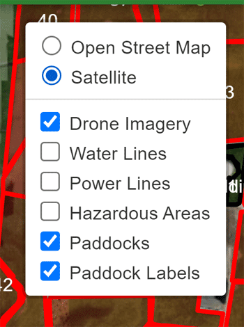
The top group of layers are the base layers. These are the layers that are always visible on the map. You can only have one base layer visible at a time.
The bottom group of layers are the extra layers. These are layers that you can add on top of the base layer. You can have multiple extra layers visible at a time. The layers "Paddocks" and "Paddock Labels" are always visible.
To have other layers like drone imagery or hazardous areas added, you will need to contact support.
Viewing a Paddock
Tapping on any paddock will open up a menu from the bottom - you can drag the handle on the top to make it larger.
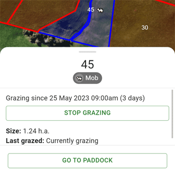
From here you can start/end a grazing, view the current grazing and view tags currently on the paddock